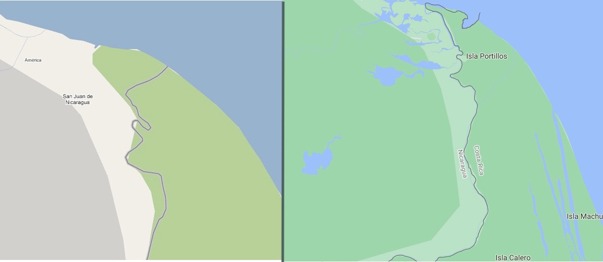
Did Google Maps almost start a war between Costa Rica and Nicaragua?
A 2010 border dispute had an unlikely protagonist.
Google Maps is a useful tool. It gives turn-by-turn directions, routes you around traffic jams, and lets you know when to invade a neighboring country.
Wait, what?
For today’s story, let’s explore the 2010 Nicaragua-Costa Rica border dispute, which earned worldwide fame as the “Google Maps War” — even though it was anything but.
To simplify a lot of tense history, Costa Rica’s northeastern border with Nicaragua is determined by the Río San Juan. This has caused friction on several occasions, because rivers change their path over time, and because the Río San Juan forms a large and ill-defined delta where it meets the Caribbean Sea.
The situation escalated in October 2010, when Nicaraguan troops arrived on Isla Calero and began dredging operations. The Isla Calero wetlands are on the Costa Rican side of the Río San Juan.
Nicaragua’s claim to the land? According to President Daniel Ortega, it was Nicaraguan territory based on the path of the Río San Juan when the border treaties were established in the 1800s.
“Nicaragua has the right to dredge the San Juan River to recover the flow of waters that existed in 1858,” Ortega said.
Minor border disagreements between two small countries don’t typically attract much international attention. But then Google Maps got involved when Nicaraguan leader Edén Pastora reportedly mentioned that even the website showed the disputed area in Nicaraguan territory:
Needless to say, news of an impending “Google Maps War” sparked widespread attention, from Wired (“Nicaraguan invasion? Blame Google Maps”) to The Atlantic (“Google Maps Nearly Starts a War”).
The truth wasn’t quite as salacious. First, Costa Rica has no army and is “perpetually neutral,” meaning war is never its answer. As a constitutional prosecutor wrote in 2003, “Costa Rica cannot declare war on anyone, as it has renounced it.”
Second, while Pastora may have alluded to Google Maps, his main rationale for entering Costa Rica was based on his understanding of the border treaty. It just so happened that Google Maps seemed to agree with his interpretation.
“The maps are not going to tell me where the borders are; the treaties are,” Pastora said at the time.
Whether or not Google Maps actually played a role in Nicaragua’s decision to claim Costa Rican land, the tech giant quickly got dragged into the international spat.
Costa Rica petitioned Google and asked it to fix the map. Nicaragua, in turn, “formally requested” Google to reject Costa Rica and keep the maps as they were.
Google, suddenly forced to act as a de-facto arbitrator, collaborated with the U.S. Department of State and decided their maps were indeed incorrect. In other words: They agreed with Costa Rica’s interpretation.
So too did an international court. Costa Rica initiated proceedings against Nicaragua at the International Court of Justice for “unlawful incursion, occupation and use of Costa Rican territory,” including claims of environmental damage to protected wetlands.
The International Court of Justice “decided the sovereignty dispute in favor of Costa Rica, rendering Nicaragua’s activities unlawful under international law.”
Eventually, Nicaragua was sentenced to pay compensation for the case, and the “Google Maps War” — that wasn’t really caused by Google Maps and wouldn’t have become a war — officially ended.
As for Google? It issued a reminder that while “Google Maps are of very high quality and Google works constantly to improve and update existing information, by no means should they be used as a reference to decide military actions between two countries.”
So the next time you want to invade a foreign territory, use Apple Maps instead.
Support The Costa Rica Daily
It takes quite a bit of time to research and write these stories. Your support helps pay for the caffeine that makes this possible:


